When Streets Became Numbered
When streets became numbered is a story of urban change: learn how systems spread, why they differed and what their patterns still reveal about a place.
The common mistake is to assume that street numbering arrived everywhere as soon as cities grew. That neat story obscures the real cost of change: residents had to learn unfamiliar labels, while officials had to fit them around streets and property boundaries already in use. When streets became numbered depended on local needs, and the systems that followed still carry traces of that process.
Numbering developed unevenly, rather than through one invention adopted by every town at once. In Britain and elsewhere in Europe, authorities increasingly formalised street names and house numbers as urban administration, postal services and property records demanded clearer ways to identify premises. The timing and method differed from place to place; a numbering scheme might be introduced by a municipal authority, revised as a district expanded, or laid over older habits of identifying a home by its occupant, trade or nearby landmark.
Why did towns begin numbering houses?
A town could be familiar to its residents and still be difficult for an outsider to describe. A house might be known as the baker’s, or as the building beside a churchyard, but those clues relied on local memory. As streets filled with more homes and businesses, a shared address became useful for administration as well as everyday directions.
Growing government and commercial record-keeping helped make that change practical. Officials needed to identify premises for tasks such as taxation and conscription; postal services needed a reliable destination for letters. These pressures did not produce identical systems everywhere, but they encouraged authorities to make locations more legible on paper and on the street.
Numbering was not simply a response to population growth. It also reflected a shift towards managing the city through named routes and identifiable properties, rather than relying only on personal connections and local landmarks.
How did numbering spread through cities?
There was no single rollout that transformed every street. Local authorities could number buildings as part of a wider effort to organise streets, update records or improve postal addressing. Existing streets might be numbered in stages, while new developments could receive numbers as plots and entrances were laid out.
In some places, numbering followed a sequence along one side and continued on the other; elsewhere, odd and even numbers were placed opposite each other. Some systems started at a central point, while others began at an end of the street or used a block-based pattern. These choices were local conventions, not evidence of one universal model spreading unchanged.
Older names and habits often persisted alongside the new labels. A building might still be recognised by its trade or a landmark even after it gained a formal number. Numbering supplemented local knowledge; it rarely erased it overnight.
What do old numbering patterns reveal?
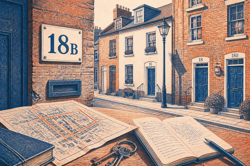
A street’s numbers can hint at how its built form changed. Gaps, lettered suffixes and irregular sequences may reflect new entrances inserted between existing properties, subdivisions, amalgamated plots or a street that was extended. A number alone cannot identify the cause, but it can prompt a closer look at the route and its buildings.
Compare a row of older terraces with a newer block set behind them. The terraces may have individual street-facing doors, while the block may have one main entrance serving several flats. A numbering scheme has to make both arrangements findable, even though their physical layouts differ.
Say you are trying to locate a fictional workshop at “18B Mill Lane”. You start with the street name and number, notice that nearby doors run in an odd-even pattern, then look for the lettered entrance beside number 18. If the entrance is set back in a courtyard, the address narrows the search but does not settle which door to use; a building sign or clear direction from the occupant supplies that final clue. The result is a better reading of the address, not a claim that the numbering itself explains the building’s history.
Why do systems remain different from street to street?
Numbering has to accommodate the city it inherits. A lane may bend, split into a court or meet a new road; a large building may have several entrances, while a group of homes may share one frontage. Renumbering every property to make the sequence look tidy can disrupt familiar addresses and records, so authorities may instead use suffixes, ranges or building names.
These irregularities are part of the urban record. They show where a street has been extended, divided or adapted, though local maps and property records are needed to establish what happened. A tidy sequence can be convenient, but an imperfect one may preserve continuity for residents.
When a number looks surprising, check the street’s own pattern before assuming it is an error.
How can you read an unfamiliar numbering scheme?
Start with the street name, then compare the destination with nearby numbers and entrances. Do not assume that a higher number always means farther from the centre: the sequence may run from a junction, follow a local block or change where the street branches.
- If odd and even numbers appear on opposite sides, use the matching side to narrow the search; if they do not, follow the visible sequence on both sides instead.
- If numbers rise steadily towards a junction, treat that junction as a likely reference point; if they do not, check a local map or street sign for the route’s numbering convention.
- If the address includes a lettered suffix, look for that exact letter at the entrance; if it is absent, check for a separate building name or ask the occupant to identify the door.
- If several homes share one street-facing entrance, use the flat or unit identifier as well; if there is no visible directory, contact the resident for the correct internal entrance.
- If the number is hidden by planting or a gate, compare the nearest visible addresses; if the sequence remains unclear, use the building name or a map pin rather than guessing.
- If a courtyard or passage lies between the street and the property, check for signs at both the street entrance and the inner doorway; if no sign identifies the destination, request a plain-language direction from the occupant.
What do people ask about when streets became numbered?
Did every city number its streets at the same time?
No. Numbering was adopted unevenly, shaped by local administration, postal needs and the form of existing streets. A town’s records and maps are the best way to establish when its own system was introduced.
Were house numbers created mainly for the post?
Postal delivery was one important reason for clearer addresses, but administration and property records also benefited. The balance differed between places, so it is misleading to assign every scheme a single cause.
Why do some streets have gaps in their numbers?
A gap can result from changes to plots, buildings or street layouts, or from a local numbering convention. It does not by itself prove that a property has been demolished or renumbered.
Can numbering tell you how old a building is?
Not reliably. Numbers may be assigned or changed after a building is erected, and newer buildings can inherit a place in an older sequence. Use maps, records and architectural details together when investigating a property’s history.
What does street numbering still tell us?
When streets became numbered, the change was more than a fresh set of plaques: it was part of a gradual shift towards recording and managing urban places through standardised addresses. Its uneven history remains visible in odd sequences, suffixes and the coexistence of formal numbers with local names.
The phrase when streets became numbered has no single answer for every city. To read a particular street well, compare its numbers with its entrances, map and local records; the gaps and exceptions may be as revealing as the orderly stretches.